 Catàleg local de Mallorca
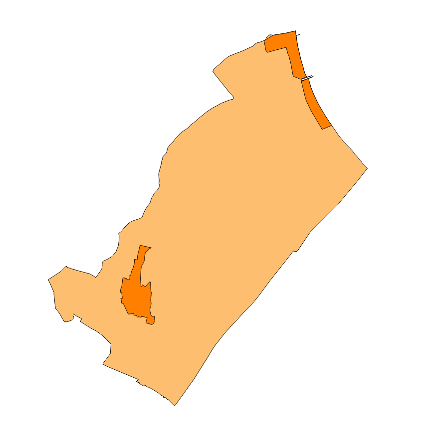
muro
Type of resources
Available actions
Municipios
INSPIRE themes
Keywords
Contact for the resource
Provided by
Years
Formats
Representation types
Scale
-
Data set that makes up the points of interest of the municipalities of Mallorca, except Palma. The data corresponds to the year 2025. The sources of the data set are the information provided by the town councils and the Survey of Infrastructures and Local Facilities (EIEL) for the cases of public facilities. Scale: 1:1,000. Reference system: ETRS89, zone 31 (EPSG: 25831)
-
Data set containing the management areas of the municipality of Muro. The cartography was taken from the 2003 Revisión of the Muro PGOU. The AM.ForestManagementArea layer is a polygon layer and contains managed, restricted, or regulated forest areas that follow the INSPIRE data model. Scale 1: 5,000. The reference system: ETRS89. Projection system: UTM zone 31. Storage format: PostgreSQL.
-

Cartography of the Utility And Governmental Services of the municipality of Muro. Reference system: ETRS89. Projection system: UTM fus 31. Storage format: PostgreSQL
-
Cartography of the network of roads, roads and streets of the municipality of Muro. It refers to the topic Transportation Networks in Annex I of the INSPIRE Directive. Mapping generated in 2014. The sources are the streets and paths of the Cartociudad's project, wich are update with the staff's knowlege of the council. Scale 1: 2,000 the streets and scale 1: 5,000 the roads and roads. Reference system: ETRS89. Projection system: UTM fus 31. Storage format: PostgreSQL.
-
Data set of the subject Using the soil of INSPIRE, generated from the cartography of the Subsidiary Standards of Muro, approved in 2003. It consists of three layers: Spatial plan, Zoning elements and Supplementary regulation. The data model and the symbology of the data set follow the specifications of the theme of Annex III of the European Directive INSPIRE, Land use, specifically of the scheme Planned land use. Urban elements are digitized at 1: 2,000 scale and rustic elements, at 1: 5,000 scale. The reference system: ETRS89. Projection system: UTM fus 31. Storage format: PostgreSQL.
-
Areas of possible erosion risk according to the 2003 PGOU de Muro Review. Map scale 1: 25,000. Reference system of the ETRS89 file, axle 31 (EPSG: 25831). Original format dwg i pdf. The PGOU de Muro is the integral planning tool of the municipal territory, defines the basic elements of the general and organic structure of the territory; classifies and classifies the soil, establishes the legal regime of classes and categories, determines the permissible uses in the soil and the intensity in which they can be developed, and establishes the program of action for the development of their forecasts. The PGOU de Muro of 2003 was drafted to implement Royal Decree 2159/1978 of June 23, which approved the Regulation of Planning for the development and application of the Law on Soil Regime and Urban Planning.
-
Data set containing elements and areas protected by municipal legislation. The protection is provided by the Subsidiary Regulations of the municipality of Muro in 2003. The Protected layer. Sites recognize all protected elements (deposits, mills, possessions, natural areas, etc.). We also find several layers according to the type of Designation, Scheme of Designation and Protection Classification. Urban elements are digitized at 1: 1,000 scale and rustic elements, at 1: 5,000 scale. The reference system: ETRS89. Projection system: UTM fus 31. Storage format: PostgreSQL.
-
General network of sewer and distribution according to the Muro's PGOU Review of 2003. This map includes the main elements that intervene in the general sewer system and potable water network. Map scale 1: 25,000. Original format dwg i pdf. Original map reference system in ED50 (European Datum), axle 31.
-
Cartography of the toponymy of the municipality of Muro. The names refer to the topics of the INSPIRE Directive Utility And Governmental Services, Land Use, Protected Sites and Transport Network of the INSPIRE Directive. Cartography generated in 2015. The sources are the Muro Subsidiary Rules of 2006 for the names of Protected Places and Land Use; and the CartoCiudad project, version 2012, for the names of Transports. The names of the urban elements are on a scale of 1: 2,000 and the names of the elements of rustic, on a scale of 1: 5,000. Reference system: ETRS89. Projection system: UTM fus 31. Storage format: PostgreSQL.
-
Data set containing the addresses of the urban center of Muro and a few kilometers from the rustic area of the municipality. Cartography was extracted from the Cartociudad project of 2012, a state project that collects all spatial information related to directions and roads. The AD.Addresses layer is a layer of points and contains the addresses or portal numbers and various attributes that follow the Cartociudad data model and INSPIRE. Scale 1: 2,000. The reference system: ETRS89. Projection system: UTM fus 31. Storage format: PostgreSQL.